
Weather & Disasters · 4 views
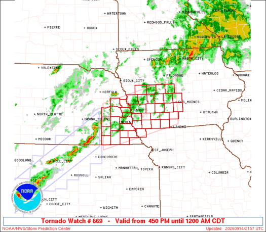
SPC Tornado Watch 669 Status Reports
STATUS REPORT #4 ON WW 669 VALID 150330Z - 150440Z SEVERE WEATHER THREAT CONTINUES RIGHT OF A LINE FROM 15 ENE FNB TO 15 NNE SDA TO 15 E DSM. ..SQUITIERI..09/15/26 ATTN...WFO...DMX...OAX...EAX...

AI Summary
The Storm Prediction Center issued Status Report #4 for Watch 669, covering 03:30 Z to 04:40 Z on 15 September 2026, indicating the severe weather threat remained east of a line from 15 ENE FNB to 15 NNE SDA to 15 E DSM. The report listed Iowa counties under continued threat, including Adams, Clarke, Page, Ringgold, Taylor, Union and Warren. Earlier, Status Report #3 for the same watch (valid 01:55 Z to 02:40 Z) described the threat east of a line from 40 ENE CNK to 15 NNW BIE to 50 SE DNS to 15 W FOD, and named additional Iowa counties such as Adair, Boone, Dallas, Fremont and others, as well as Missouri counties MOC005.
AI summaries can be wrong sometimes—always verify important details using the source article.
How AI & Automation are usedMore from Weather & Disasters
Continue reading recent Weather & Disasters coverage
- There are no tropical cyclones at this time.Continue reading
- Special Weather Statement issued September 15 at 1:32AM MDT by NWS Grand Junction COContinue reading
- Small Craft Advisory issued September 14 at 10:56PM AKDT until September 16 at 4:00PM AKDT by NWS Juneau AKContinue reading
- Small Craft Advisory issued September 14 at 10:56PM AKDT until September 16 at 7:00PM AKDT by NWS Juneau AKContinue reading
Support HappeningNow
Independent AI-powered news analysis is reader-supported. Your contribution helps cover infrastructure, summaries, and continued platform development.
Support HappeningNow