
Weather & Disasters · 3 views
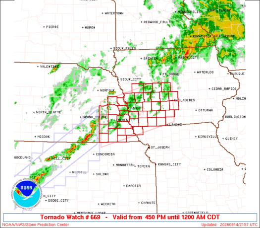
SPC Tornado Watch 669
SEL9 URGENT - IMMEDIATE BROADCAST REQUESTED Tornado Watch Number 669 NWS Storm Prediction Center Norman OK 450 PM CDT Mon Sep 14 2026 The NWS Storm Prediction Center has issued a * Tornado Watch for portions of Western into Central Iowa…

AI Summary
The Storm Prediction Center issued Tornado Watch 669 for parts of western and central Iowa, far northwest Missouri, and eastern Nebraska, effective Monday from 4:50 PM to midnight CDT. The watch warns of a couple of possible tornadoes, scattered damaging winds up to 80 mph, and large hail up to 2 inches in diameter. Severe thunderstorms are expected to develop and intensify this evening, with the greatest tornado risk linked to supercell activity. A lingering threat may extend into the late evening as storms grow into a squall line. The watch area spans roughly 60 miles north and south of a line from 30 miles west‑southwest of Lincoln, NE, to 5 miles northeast of Des Moines, IA.
AI summaries can be wrong sometimes—always verify important details using the source article.
How AI & Automation are usedMore from Weather & Disasters
Continue reading recent Weather & Disasters coverage
- There are no tropical cyclones at this time.Continue reading
- Special Weather Statement issued September 15 at 1:32AM MDT by NWS Grand Junction COContinue reading
- Small Craft Advisory issued September 14 at 10:56PM AKDT until September 16 at 7:00PM AKDT by NWS Juneau AKContinue reading
- Small Craft Advisory issued September 14 at 10:56PM AKDT until September 16 at 4:00PM AKDT by NWS Juneau AKContinue reading
Support HappeningNow
Independent AI-powered news analysis is reader-supported. Your contribution helps cover infrastructure, summaries, and continued platform development.
Support HappeningNow