
Weather & Disasters · 1 views
SPC Severe Thunderstorm Watch 664 Status Reports
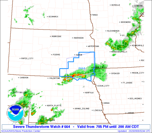
STATUS REPORT #2 ON WW 664 VALID 080235Z - 080340Z SEVERE WEATHER THREAT CONTINUES RIGHT OF A LINE FROM 20 SSE 9V9 TO 25 ESE FSD. ..CHALMERS..09/08/26 ATTN...WFO...FSD... && STATUS REPORT FOR WS 664 SEVERE WEATHER THREAT CONTINUES FOR TH…

AI Summary
The Storm Prediction Center issued Status Report #2 for Severe Thunderstorm Watch 664, valid from 023 Z to 340 Z on 8 September 2026. The report notes that the severe weather threat persists to the right of a line extending from 20 SSE 9V9 to 25 ESE FSD, affecting the listed forecast zones (SDC009, 023, 027, 043, 053, 067, 083, 125, 135, 080340).
AI summaries can be wrong sometimes—always verify important details using the source article.
How AI & Automation are usedMore from Weather & Disasters
Continue reading recent Weather & Disasters coverage
- There are no tropical cyclones at this time.Continue reading
- Severe Thunderstorm Warning issued September 7 at 10:20PM CDT until September 7 at 11:00PM CDT by NWS Sioux Falls SDContinue reading
- Severe Thunderstorm Watch issued September 7 at 9:57PM CDT until September 8 at 2:00AM CDT by NWS Sioux Falls SDContinue reading
- Hurricane Warning issued September 7 at 4:57PM HST by NWS Honolulu HIContinue reading
Support HappeningNow
Independent AI-powered news analysis is reader-supported. Your contribution helps cover infrastructure, summaries, and continued platform development.
Support HappeningNow