
Weather & Disasters
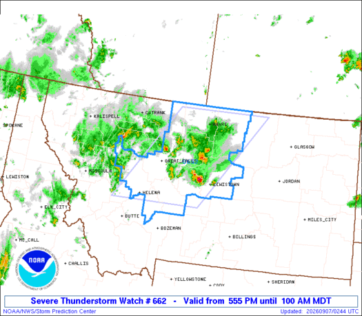
SPC Severe Thunderstorm Watch 662 Status Reports
STATUS REPORT #3 ON WW 662 VALID 070330Z - 070440Z SEVERE WEATHER THREAT CONTINUES RIGHT OF A LINE FROM 20 NNE LWT TO 55 NNW LWT TO 35 NE HVR. ..KERR..09/07/26 ATTN...WFO...TFX... && STATUS REPORT FOR WS 662 SEVERE WEATHER THREAT CONTINU…

AI Summary
The Storm Prediction Center issued Status Report #3 for Severe Thunderstorm Watch 662, covering the period 070330Z to 070440Z on 9 July 2026. The report notes that the severe weather threat persisted to the right of a line extending from 20 NNE LWT to 55 NNW LWT and to 35 NE HVR. The affected forecast zones include MTC005, 007, 015, 027, 041, and 070440. The report was coordinated with the Twin Falls, Idaho Weather Forecast Office.
AI summaries can be wrong sometimes—always verify important details using the source article.
How AI & Automation are usedMore from Weather & Disasters
Continue reading recent Weather & Disasters coverage
- There are no tropical cyclones at this time.Continue reading
- Special Marine Warning issued September 7 at 12:59AM EDT until September 7 at 3:00AM EDT by NWS Tallahassee FLContinue reading
- Severe Thunderstorm Warning issued September 6 at 10:58PM MDT until September 6 at 11:30PM MDT by NWS Great Falls MTContinue reading
- M 3.7 - 20 km E of Castle Rock, WashingtonContinue reading
Support HappeningNow
Independent AI-powered news analysis is reader-supported. Your contribution helps cover infrastructure, summaries, and continued platform development.
Support HappeningNow