Weather & Disasters · 3 views
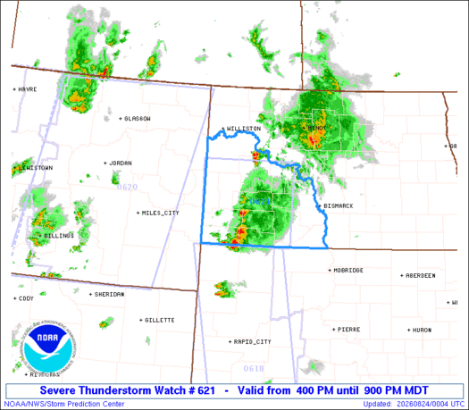
SPC Severe Thunderstorm Watch 621
The Storm Prediction Center issued Severe Thunderstorm Watch 621 for parts of southwest North Dakota, effective from 4 p.m.

AI Summary
The Storm Prediction Center issued Severe Thunderstorm Watch 621 for parts of southwest North Dakota, effective from 4 p.m. to 9 p.m. MDT on Sunday, August 23. The watch highlights the potential for scattered large hail up to two inches in diameter and isolated damaging wind gusts reaching 75 mph. Forecasts indicate a few supercell storms capable of producing the described hail and wind threats throughout the afternoon and evening. The watch area extends roughly 60 miles east and west of a line from about 55 miles north of Dickinson, ND, to 30 miles west of Lemmon, SD. A Severe Thunderstorm Watch signifies that conditions are favorable for such storms in the specified region.
Read full article on SPCAI summaries can be wrong sometimes—always verify important details using the source article.
How AI & Automation are usedMore from Weather & Disasters
Continue reading recent Weather & Disasters coverage
- There are no tropical cyclones at this time.Continue reading
- Special Marine Warning issued August 23 at 7:39PM EDT until August 23 at 9:15PM EDT by NWS Cleveland OHContinue reading
- Severe Thunderstorm Warning issued August 23 at 6:00PM CDT until August 23 at 7:00PM CDT by NWS Bismarck NDContinue reading
- Special Marine Warning issued August 23 at 6:17PM EDT until August 23 at 7:15PM EDT by NWS Melbourne FLContinue reading
Support HappeningNow
Independent AI-powered news analysis is reader-supported. Your contribution helps cover infrastructure, summaries, and continued platform development.
Support HappeningNow