
Weather & Disasters · 51 views
SPC Severe Thunderstorm Watch 506
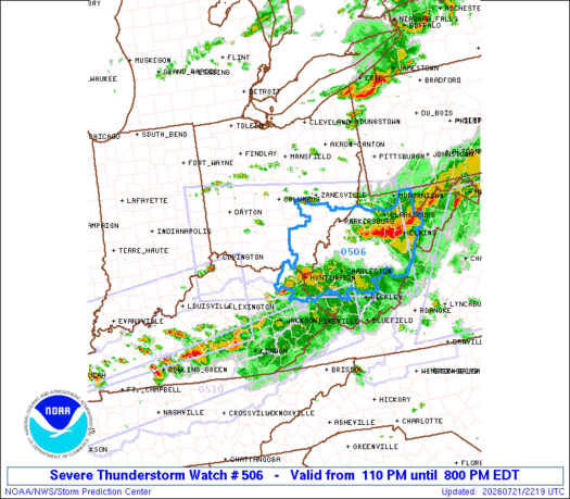
WW 506 SEVERE TSTM IN KY OH PA WV 211710Z - 220000Z URGENT - IMMEDIATE BROADCAST REQUESTED Severe Thunderstorm Watch Number 506 NWS Storm Prediction Center Norman OK 110 PM EDT Tue Jul 21 2026 The NWS Storm Prediction Center has issued a…

AI Summary
The Storm Prediction Center issued Severe Thunderstorm Watch 506 for parts of far southeast Indiana, far northern Kentucky, central and southern Ohio, southwest Pennsylvania, and West Virginia, effective Tuesday afternoon from 1:10 p.m. to 8:00 p.m. EDT. The watch highlights scattered damaging wind gusts up to 70 mph as the primary threat, with the possibility of large hail up to 1.5 inches in diameter and a low probability of one or two brief tornadoes. Thunderstorm activity is expected to increase as a pre‑frontal trough and cold front move through the region, creating strong to severe environmental conditions. The linear convective mode favors damaging gusts, while low‑level shear could support isolated, line‑embedded tornadoes.
AI summaries can be wrong sometimes—always verify important details using the source article.
How AI & Automation are usedMore from Weather & Disasters
Continue reading recent Weather & Disasters coverage
- Flash Flood Warning issued September 28 at 7:56PM MST until September 29 at 2:45AM MST by NWS Flagstaff AZContinue reading
- Flash Flood Warning issued September 28 at 8:08PM MDT until September 29 at 4:00AM MDT by NWS Salt Lake City UTContinue reading
- Atlantic Tropical Weather OutlookContinue reading
- Flood Warning issued September 28 at 9:03PM CDT until October 1 at 11:00AM CDT by NWS Quad Cities IA ILContinue reading
Support HappeningNow
Independent AI-powered news analysis is reader-supported. Your contribution helps cover infrastructure, summaries, and continued platform development.
Support HappeningNow